Welcome to Country
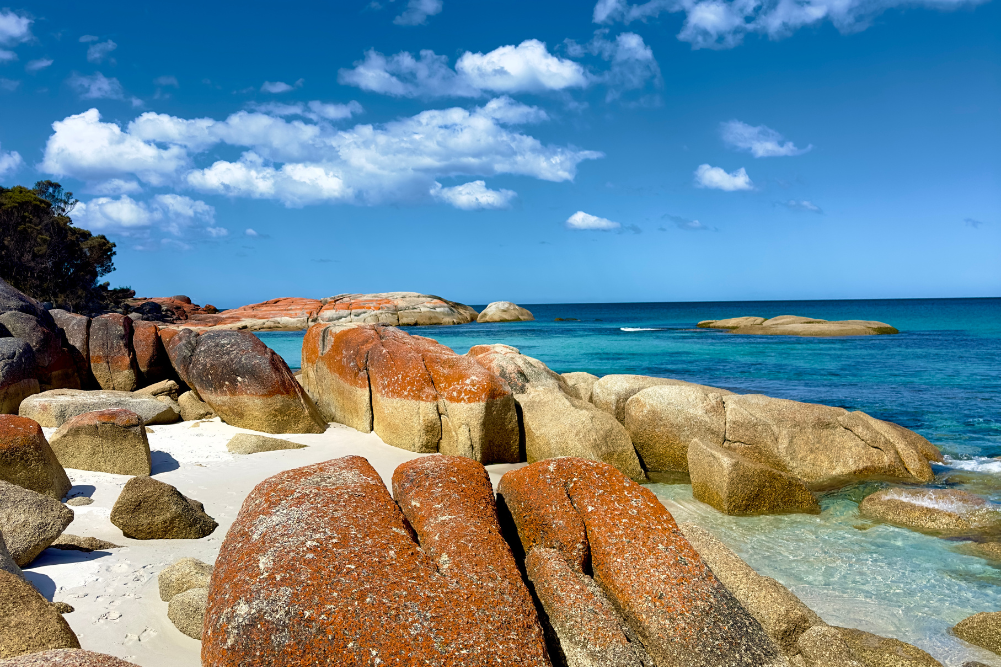
Paddling through the shallows, spooking tiny shovel-nosed rays as I go, I am pulled far from the shore by the Dampier Archipelago’s island-studded seascape. Across Mermaid Sound, I glide through Searipple Passage and beach my boat on Dolphin Island to rockhop inland through the spinifex.
Beyond the sand where I’ll pitch my tent for the night, rugged piles of fractured ironstone rubble take the place of trees. These precious shards — etched with mesmerising, 47,000-year-old petroglyphs — are part of the largest concentration of ancient Indigenous rock art the world has ever seen.
This unlikely outdoor gallery is a stunning find, and on Dolphin Island I have it entirely to myself.
Found right across the Dampier Archipelago’s scatter of 42 coral-fringed isles, and dominating mainland hills too, these petroglyphs preserve the long and sacred history of the Pilbara’s traditional custodians, known collectively as the Ngarda-Ngarli.
Safeguarding the lion’s share of rock art, Murujuga National Park was belatedly declared in 2014, sending this outstanding heritage site on a rapid trajectory towards an eminent World Heritage listing. But the rock art is only the beginning. Scratch the surface of this hugely underrated west coast destination and you’ll discover pristine coral reefs and translucent seas, a “staircase to the moon” to rival anything Broome has to offer, and away from the sea spring-fed oases and hiking and biking trails in Millstream Chichester National Park.
And when you finally come in from the wilds, the twin towns of Dampier and Karratha serve up a soothing slice of laidback Pilbara luxury with locally brewed ales, and a handful of places to sit and sip with sand on your feet. Despite its obvious allure, this fascinating coastline has a catch that even the best sunsets and seascapes can’t undo — an elephant in the room — and it literally lights up the sky.
Corrupting its beauty, the flaring spires of a natural gas plant ignite the night, towering above Dampier at the tip of the Burrup Peninsula. Close by are a salt works and iron ore loading facilities, and a fertiliser plant that rates as one of the world’s largest. If not for this utterly incongruous industry, Dampier would turn far more heads. But the best scenes lie beyond, so I set my sights on the deep blue and start paddling.
Boating on Mermaid Sound
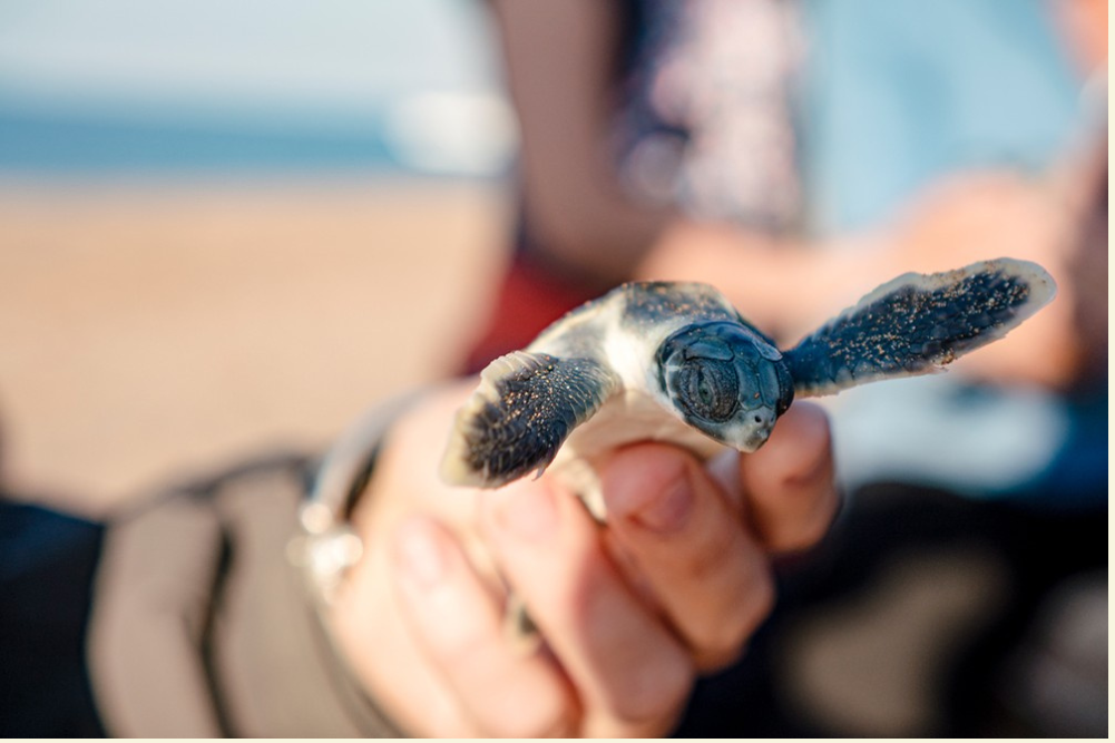
Girthed by a marine park that protects the richest marine biodiversity in Western Australia, Dampier’s idyllic chain of rocky isles provides a rare, reef-fringed oasis. Coral-filled lagoons nurture more than 4500 marine species, along with dugongs and dolphins, and three species of nesting sea turtles and locally endangered hawksbills.
Humpbacks migrate past from July to September, coinciding with the season of cool, mild weather that attracts boaties and paddlers too. If you’re feeling adventurous and can arm yourself with camping gear, you can spend up to five free nights on the closest islands, snorkelling, hiking and seeking out as much rock art as you can find. With all 42 isles located within a 45km radius of the mainland, day trippers need only rent themselves a boat to island-hop their days away.
I bring my own kayak, pack it with water, food and sleeping gear, and slip away beneath a sunny sky into Flying Foam Passage. The reef beneath my boat couldn’t be more colourful, but this waterway has a long, dark past. In the 1880s, cyclones had a habit of sending boats to the seabed, wrecking entire fleets of pearling luggers and merchant ships that hunkered down inside this passage.
It’s named for the 33-ton coastal schooner Flying Foam, which disappeared without a trace in 1872. But white settlers delivered history’s deadliest blow in an 1868 retaliation battle that annihilated upwards of 150 Yaburara people and became retrospectively known as the Flying Foam Massacre.
I feel the weight of all this turmoil rippling the ocean still, pushing me north to Legendre Island to ride the swell along the western sides of Gidley and Angel Islands. Named by pioneering seafarers with obviously poetic leanings, these sandy isles lure me into their protected lagoons to ogle a dazzling cavalcade of reef fish, and to surf with dolphins. I pitch my tent and fall asleep with salt in my hair, waking at dawn to paddle out and watch dugongs grazing the seabed through six metres of the clearest water on earth.
While anglers fish the oyster stacks on Angel Island’s southern tip, I spend my time under the sea, eyeballing gleaming, lime-and-tangerine parrotfish nibbling loudly on coral. Across Mermaid Sound there are more islands to explore, but back on the mainland, a light show is about to take place and it just won’t wait.
Moonrise at Hearson Cove
The shimmering golden stairway that rises to meet the moon over Hearson Cove is the lesser-known twin to Broome’s Roebuck Bay spectacle. When the tide retreats, exposing shallow, arcing mudflats at day’s end, Hearson Cove provides the moon’s most spectacular canvas.
This fleeting phenomenon — a negotiation between the tide and the full moon — takes place for three nights running from March to October. Catch it if you can, arriving before dark with a picnic rug and hamper, to nestle into the sand and witness the glorious handover that takes place as the sun disappears and the moon takes centre stage.
By day, Hearson’s sandy cove is a calm, sheltered place to swim and play, bound by rugged hills on the edge of Nickol Bay. When the low tide steals back its sea, you can walk for miles, exploring across the exposed mudflats. To get there, follow Hearson Cove Road a short distance out of Dampier and drive past the boardwalk stroll at Ngajarli until you reach the beach.
It’s hard to believe that this perfect little bay could have kick-started Karratha’s considerable commercial hubris, but when explorer FT (Frank) Gregory came ashore back in 1861, his great vision for pastoralism and pearling industries earmarked this destination for opportunists. The balance is still skewed in favour of industrial giants, but nature continues to turn heads here.
Petroglyphs aplenty
The Pilbara’s traditional custodians, the Ngarda-Ngarli, preside over a substantial historical legacy. From the Burrup Peninsula, chiselled art canvases extend right across the Dampier Archipelago and under the sea too. In 2020, scientists discovered Australia’s first underwater ancient Indigenous archaeological site at Cape Bruguieres on North Gidley Island. Amongst the 269 artefacts unearthed were hundreds of stone tools and grinding stones, and an 8500-year-old underwater freshwater spring.
If you are fortunate enough to be exploring by boat, some truly impressive rock canvases await discovery on Enderby and Rosemary Islands, but you can immerse yourself equally well with a walk around Ngajarli on the mainland.
Located close to Dampier on Hearson Cove Road, Ngajarli’s 700-metre-long boardwalk provides universal access and enough interpretive signage to infuse your experience with meaning. You might spot etchings of animal tracks and spiritual beings, long extinct megafauna and thylacines, and what is believed to be the oldest depiction of a human face — all of it etched into the ironstone’s red-black patina of desert varnish.
These petroglyphs steal the limelight, but shorelines here are littered with shell middens and fish traps, and the lofty ironstone hills guard ancient archaeological sites where standing stones, ceremonial grounds and caves of stone artefacts, quarries and graves have all been found.
What astounds many visitors (and has long frustrated conservationists) is the time it took for this remarkable heritage to be safeguarded from industrial interests. Only in 2013 was Murujuga National Park finally declared WA’s 100th national park, protecting the area known as Ngajarli near Hearson Cove. You can access the site’s boardwalk any time, but only at sunset is the rock art revealed in glorious golden hues.
Guided excursions with Ngurrangga Tours impart a deeper knowledge as you tour Ngajarli and include Indigenous-led coastal foraging and Dreamtime stories too (three hours, adults $150, ngurrangga.com.au).
Calling Barrimurdi
Across the thirsty Pilbara plains, a surprising tropical oasis lures travellers inland to the palm-fringed banks of Jirndawurrunha Pool. Nestled in the shade of towering millstream palms, this sacred, lily-covered wetland once supplied great inter-tribal feasts with fish, fruits and edible plants, gathered straight from its streams and lush, fringing grasslands. The Yindjibarndi people would hunt for reptiles as well as for euro kangaroos lured to this verdant spot from the dusty plains beyond.
Poised on its banks, 100-year-old Millstream Homestead tells the story of what happened next, when sheep came to these isolated wetlands and the station held the Australian record for the highest price paid for fleece. Well preserved as a free-to-visit interpretive centre for the national park that protects it, it is packed with pastoral treasures and chronicles a vibrant Indigenous history too.
Jirndawurrunha Pool is too sacred for swimming, but another resting place at Deep Reach Pool is where you go to paddle, fish and float. The Yindjibarndi people call it Nhanggangunha, and it’s home to Barrimurdi, the Warlu serpent of their dreaming stories. Fed by an ancient aquifer, it’s the largest of the Fortescue River’s permanent waterholes, but you must slide into the water gently, as the Yindjibarndi do, to avoid waking the snake.
Arrive at Deep Reach Pool by car, or hike or cycle the Red Roo Trail that connects to Millstream’s Miliyanha Campground, 9km away. Set out early to avoid the midday heat, freewheeling beneath snappy gums and bloodwoods, high above the river. Within an hour you can be floating at Deep Reach, watching rainbow bee-eaters hunting on the wind and spotting a magnificent, five-metre-long Pilbara olive python, often found curled and sleeping on the riverbank.
My wintertime wander coincides with the Pilbara’s fleeting wildflower bloom. From June to August, great carpets of fuzzy purple mulla mulla colour the rust-red plains, and riverbanks bristle with sunny wattles and sennas. Revelling in it all means getting back to basics because there’s no way to see it all in a day, and a pair of national park campsites provide the only beds for miles around.
Thankfully, this is a comfortable place to rough it. The main camp at Miliyanha provides a chatty communal hub with free gas cookers, hot water on tap, drinking water, tables and interpretive displays to peruse while you stir your cooking pots. You won’t find hot showers but the campsites are big and private and usually receive nocturnal visits from endangered northern quolls and a variety of marsupial mice.
Travelling from Millstream Chichester National Park, you can off-road all the way to Karijini National Park or return to the coast via Python Pool and Mount Herbert. This mountain’s easily accessed summit rewards us with stunning coastal views, and we are up and back at the car in less than 30 minutes. The Chichester Range Camel Trail is a more committed hike that fills the better part of your day (16km/6hrs return), but both walks come highly recommended.
Karratha welcomes me back from the wilds, shaking off its reputation as a purely functional service hub with creative menus and cool sundowner joints. To kick things off, head to North West Brewing Co. for home-brewed pale ales and cod ceviche tostadas (and vego options good enough to woo diehards like me). Sunset beach picnics deserve a Bangkok-inspired spread from the Fat Buddha food truck, which you’ll have to track down on Facebook as it moves around town.
For a breezy beachfront spot to sip sunset brews with sand on your feet, none beats the laidback Port Walcott Yacht Club overlooking Nichol Bay. This watering hole is one of the region’s best-kept secrets and its views showcase a little piece of rustic Pilbara paradise.
Escape routes
Go
Karratha is located 1500km north of Perth. To reach Ngajarli in Murujuga National Park and to see Dampier’s Staircase to the Moon, drive 25km west of Karratha via Burrup Peninsula and Hearson Cove Roads. Millstream Chichester National Park is located 120km inland via sealed roads.
Visit
June to September when cool, comfortable temperatures average 13–26˚C.
Stay
Self-contained apartments at The Ranges come with a balcony and shared pool (from $217/night, therangeskarratha.com.au). Kayaker campsites on Dampier Archipelago islands are free for up to five nights. In Millstream Chichester National Park, campsites cost $11/adult and $3/child ($15 entry), payable on arrival.
Don’t miss
Stop at the Red Dog Memorial, an iron ore sculpture by Meri Forrest devoted to the original Pilbara wanderer and the west’s most famous kelpie. For organic bullet coffee and fresh bagels in Karratha, head to Empire 6714 on Sharpe Street.
Shop
Time your trip to catch the Cossack Art Awards, the richest acquisitive art award in regional Australia (free entry, three weeks in July/August).
Pack
Reef-friendly sunscreen, snorkelling gear and walking shoes.
Plan
parks.dpaw.wa.gov.au